- D/618/7406 Unit 5: Challenges of IT Security in Modern Organizations – Risks, Solutions & Best Practices
- HSC Level 2/3 Unit 012 Assignment: Care Worker Responsibilities and Ways of Working
- CIPD Level 5HR03 Assignment: Understanding Reward Approaches and Their Impact on Performance and Contribution
- CIPD level 5HR02 Assignment: Talent Management and Workforce Planning Unit Guide
- Level 3 D/615/3823 Assignment: Regulation, Protection, and Collaborative Practice in Health and Social Care
- PGM216D Assignment: Bicycle Store Sales Management Application
- MATH6033 Assignment: Epidemiological Investigation of Cardiovascular Health and Tea Consumption Risks
- EH6147 Assingment: Stakeholder Analysis for Quality Improvement in Hand Hygiene Compliance
- Assignment: Investigation of Solution Concentration Through Standard Preparation, Titration, and Colorimetry Techniques
- MATH6033 Assignment: Cardiovascular Risk and Tea Drinking: Epidemiological Analyses
- CIPD level 3 3CO03 Assignment: Core behaviours for people professionals
- DAC4B1: Personal development in adult care settings
- Unit 19 Research Project Assignment 1: Impact of Corporate Social Responsibility on Business Success & Community Wellness
- EG5022 Assignment: Georeferencing and Accuracy Assessment of a Quarry 3D Model Using Photogrammetric GCPs
- Assignment: Financial Performance and Strategic Analysis of a UK Listed Company: A CORE Evaluation and Reflective Review
- 5CNMN002W Assignment: Advanced measurement- Major measurement taking off
- K/650/2298 Level 3 Understanding Roles, Responsibilities, and Effective Partnerships in Health and Social Care
- Understanding Information and Knowledge Management in the Workplace: A Briefing for HR Professionals
- HRM7010D Strategic Use of People Analytics in Enhancing Organisational Value and Agility
- TOWN1060 Urban Planning in the UK History Sustainable Design and Future City Development
EG5016: Surveying Field Scheme (RESIT), Assignment, UOEL, UK
| University | University of East London ( UOEL) |
| Subject | EG5016: Surveying Field Scheme (RESIT) |
Learning Outcomes
- Clarify the role of the surveyor in construction projects.
- Identify the principal requirements of surveys for construction projects.
- Use surveying equipment and calculation methods to minimise error propagation.
- Evaluate problems and apply appropriate measurement and computation systems.
- Analyse the precision of measurements and resulting values.
- Use instruments and measurement techniques according to surveying principles.
- Record measurements and present results.
- Carry out simple setting out of coordinated points.
- Undertake collection and basic processing of 3D data.
- Use measurement and presentation techniques, including graphical forms.
- Demonstrate evidence of reflection on academic performance by implementing feedback given
Buy Answer of This Assessment & Raise Your Grades
TASK A : CONTROL TRAVERSE
Task :
- To establish control points around the site to be used for setting out the design.
- The coordinates of two stations can be found by resection from the yellow targets (details on Moodle)
- Each person of the group is required to observe at a minimum of one point.
- Each person of the group is required to book and reduce the observations at a minimum of one point. (thus a 3 station traverse)
- Two rounds of horizontal to be observed at each point (changing the zero each time) with a maximum spread of 20” (if not achieved extra rounds will be required until they are).
- A “Station Description” of each point is required
- Calculate the coordinates of each point.
The control is to be observed as a closed loop traverse. Each person is to calculate the traverse INDEPENDENTLY to obtain the point coordinates from the raw observations: Determine the angular and linear misclosures, apply corrections as appropriate using the Bowditch method of adjustment. The coordinates will be required for the setting out task. Check with each other, otherwise the whole group could fail by the actions of one.
Procedure
Identify the control points. The three tripod traversing technique will be used. The instrument is to be set up at each point in turn working around the traverse in an anticlockwise direction – each student is to observe and book (including reduction to measured value) the observations for at least one station. Each student is responsible for the observations at all the points. Horizontal angles are to be observed as rounds of face left and face right observations. At least two rounds should be observed with a maximum spread of 20” using different zeros. All observations must be reduced / calculated at the point before removing the instrument.
On completion, you will need to confirm that your total internal angles add up to the required amount. Calculation of the actual co-ordinates is required to be carried out as the results form the basis of the setting out task.
Levels of each station are required to be determined by vertical angles and checked using an automatic level. Bench Mark (BM) value to be taken as 5.510m OD.
TASK B: SETTING OUT (by Co-ordinates)
Task:
- To set out points (indicated by flags) to indicate the position of a proposed sculpture.
- The points are provided as co-ordinates and will need to be related to the control traverse points
Procedure:
The points need to be loaded into the total stations (don’t forget to start a new job). The first stage is to input your control point information into the database.
Set up over one of the control points (most convenient for the task) and orientate to one of the others, checking to a third to confirm direction (or you could end up setting out over the dock edge).
Find the first point in the database and the total station will show you how much to turn and how far you need to go to set the point out. Repeat for each of the points.
The points are to be independently checked and an estimate of their accuracy determined. Checks will be by taping between points and diagonals to ensure dimensional correctness. You will need to compile a table indicating what the points should be, what you actually achieved and, most importantly, the DIFFERENCE between them.
Do You Need Assignment of This Question
TASK C :
Volumes Reduced levels taken from total station 20m x 20m grid
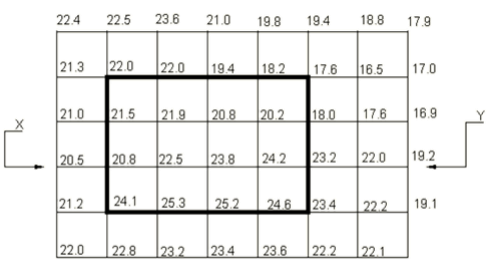
Draw a section from X-Y Contour the grid with a 1 metre interval.
Determine the volume of cut material to be removed to obtain a flat formation level (FFL) of 20m within the highlighted part of the grid.
To find the volume of each individual ‘cube’, find the average of the four corners (for each cube), remove the 20m FFL and multiply by the area of the square.
Are You Looking for Answer of This Assignment or Essay
Need help with your EG5016: Surveying Field Scheme (RESIT) assignment? Our assignment help UK service is here to support you. We offer top-notch coursework writing services tailored to your needs. UK students can pay our expert to get professional assistance and excel in their courses. Don’t let challenging assignments hold you back—contact us today and ensure your academic success with our expert guidance!
Answer